
References Projects Our Team Videos Contact
TR EN

MobileGIS Application

MobileGIS Application

Android and iOS software for GIS-supported field data collection, control, and precise positioning.

Overview

Explore

How MobileGIS Application Works

Field operations combine mapping, reporting, land registry data, parcel queries, GNSS positioning, and media collection.

MobileGIS ApplicationMapLand Registry IntegrationParcel Query IntegrationFormat SupportDetailed ReportsNational GNSS NetworkIntegration CompatibilityMedia Operations(Photo / Video)Apple iOSAndroidRegulatory Compliance

Overview

Manage Your Processes on a Single Platform with MobileGIS Application

MobileGIS Application is a mobile-based GIS application that enables institutions to manage their field operations in an integrated way with geographic data.

MobileGIS Application
360°
delivers end-to-end digital process management
MobileGIS Application is a mobile-based GIS application that enables institutions to manage their field operations in an integrated way with geographic data.
Highlights
Map
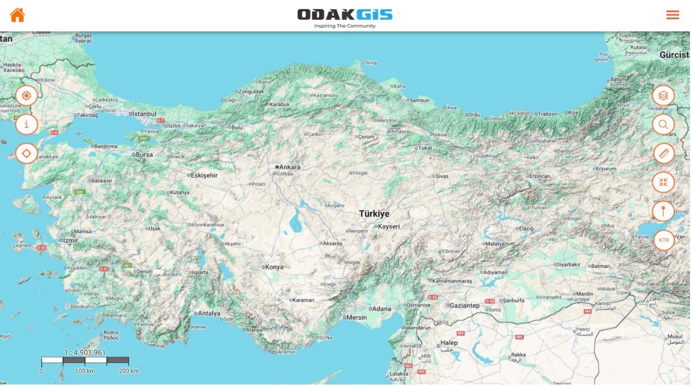
It enables real-time display of field data on a geographic map. With layer management, measurement, and drawing tools, all spatial data can be managed from the field...
It enables real-time display of field data on a geographic map. With layer management, measurement, and drawing tools, all spatial data can be managed from the field.
0172%
0284%
Format Support
It supports WMS, WFS, GeoJSON, GPX, and SQL data formats. It allows data from different GIS infrastructures to be displayed on a single platform.
0178%
0288%
Detailed Reports
Field activities, tasks, and user movements can be reported through the system by location, date, and user.
0184%
0292%

Capabilities

The Mobile Field Data Collection Process
Managed from Start to Finish

  • 01.
    Produce, verify, and control directly in the field
    Stop carrying heavy GPS devices, total stations, and measurement equipment. Make precise measurements with the tablet-integrated GPS, edit vector data, add photos and videos, verify your attribute data, access data at its source and location, lower your costs, and increase your earnings.
  • 02.
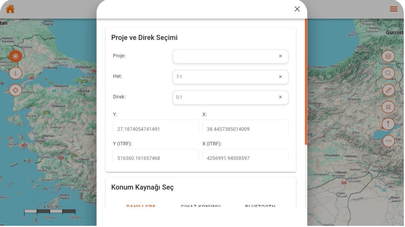
    Project and Feature Selection
    Field users can record location-based data by easily selecting the line and feature information of the active project.
  • 03.
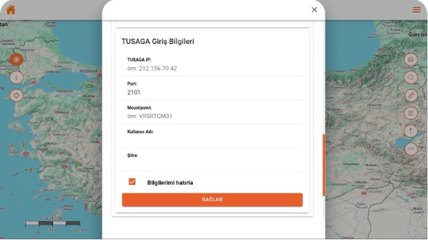
    National GNSS Network Login Screen
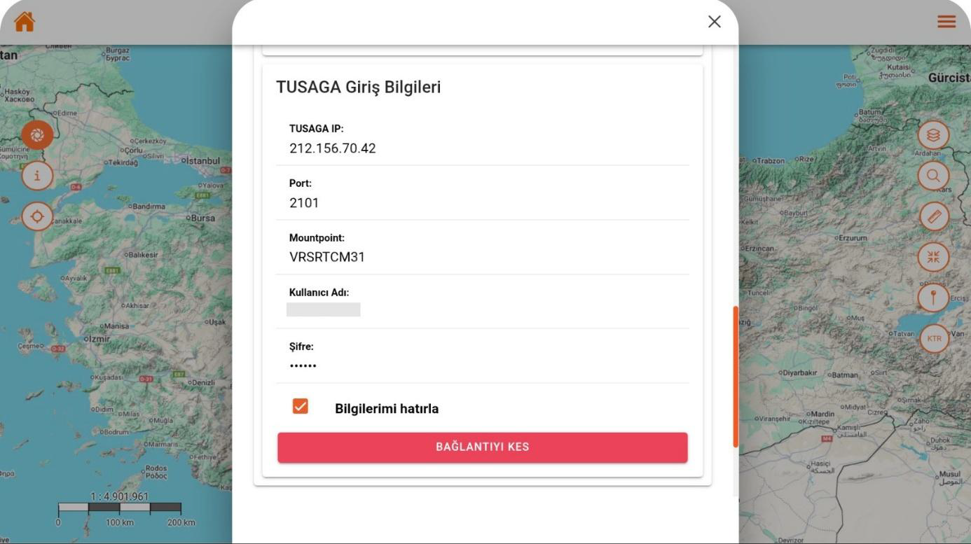
    Users can connect GNSS devices directly to the application by entering the IP, port, and mountpoint information of the Turkish National Permanent GNSS Network system.
  • 04.
    Turkish National Permanent GNSS Network Connection
    When the user successfully connects to the Turkish National Permanent GNSS Network, the system receives real-time RTK corrections and produces centimeter-accuracy positioning.
  • 05.
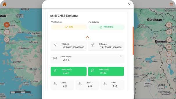
    Real-Time GNSS Position
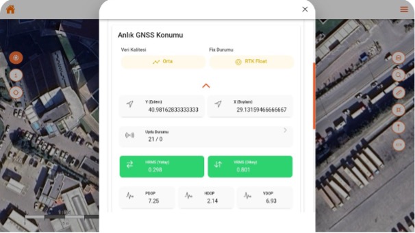
    The application displays the device’s current GNSS data with high precision and analyzes position quality at the RTK level.
  • 06.
    RTK Fixed Position Screen
    The system indicates that the GNSS receiver has switched to RTK Fixed mode, notifying the user that centimeter-level accuracy has been achieved.
  • 07.
    Media Functions
    Location-based photo and video upload from the field, integrated with vector data.
Real-TimeMapProject and FeatureSelectionNational GNSS Network LoginScreenNational GNSS NetworkConnectionReal-Time GNSSPositionRTK FixedPositionMediaFunctions

Core Capabilities

Modules that support MobileGIS Application operations

Android and iOS software for GIS-supported field data collection, control, and precise positioning.

Go to Overview

Produce, verify, and control directly in the field

Stop carrying heavy GPS devices, total stations, and measurement equipment. Make precise measurements with the tablet-integrated GPS, edit vector data, add photos and videos, verify your attribute data, access data at its source and location, lower your costs, and increase your earnings.

Project and Feature Selection

Field users can record location-based data by easily selecting the line and feature information of the active project.

National GNSS Network Login Screen

Users can connect GNSS devices directly to the application by entering the IP, port, and mountpoint information of the Turkish National Permanent GNSS Network system.

Turkish National Permanent GNSS Network Connection

When the user successfully connects to the Turkish National Permanent GNSS Network, the system receives real-time RTK corrections and produces centimeter-accuracy positioning...

Real-Time GNSS Position

The application displays the device’s current GNSS data with high precision and analyzes position quality at the RTK level.

RTK Fixed Position Screen

The system indicates that the GNSS receiver has switched to RTK Fixed mode, notifying the user that centimeter-level accuracy has been achieved.

Capability Cards

Everything Mobile Field Data Collection Requires,
in a Single Platform

The main modules are organized as concise corporate summary cards within the current page layout.

Real-Time

Produce, verify, and control directly in the field

Stop carrying heavy GPS devices, total stations, and measurement equipment. Make precise measurements with the tablet-integrated GPS, edit vector data, add photos and videos, verify your attribute data, access data at its source and location, lower your costs, and increase your earnings.
Project Feature

Project and Feature Selection

Field users can record location-based data by easily selecting the line and feature information of the active project.

National GNSS Network Login

National GNSS Network Login Screen

Users can connect GNSS devices directly to the application by entering the IP, port, and mountpoint information of the Turkish National Permanent GNSS Network system.

Turkish National Permanent GNSS Network

Turkish National Permanent GNSS Network Connection

The Turkish National Permanent GNSS Network Connection area lets you track, monitor, and manage the relevant process on a single screen, in line with the corporate workflow.

Real-Time GNSS

Real-Time GNSS Position

The Real-Time GNSS Position area lets you track, monitor, and manage the relevant process on a single screen, in line with the corporate workflow.

RTK Fixed

RTK Fixed Position Screen

The RTK Fixed Position Screen lets you track, monitor, and manage the relevant process on a single screen, in line with the corporate workflow.

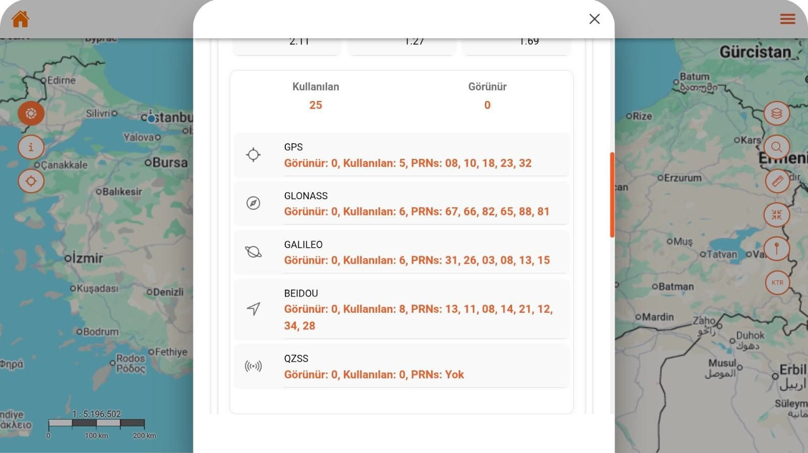
Satellite Tracking

Satellite Tracking Screen

The Satellite Tracking Screen lets you track, monitor, and manage the relevant process on a single screen, in line with the corporate workflow.

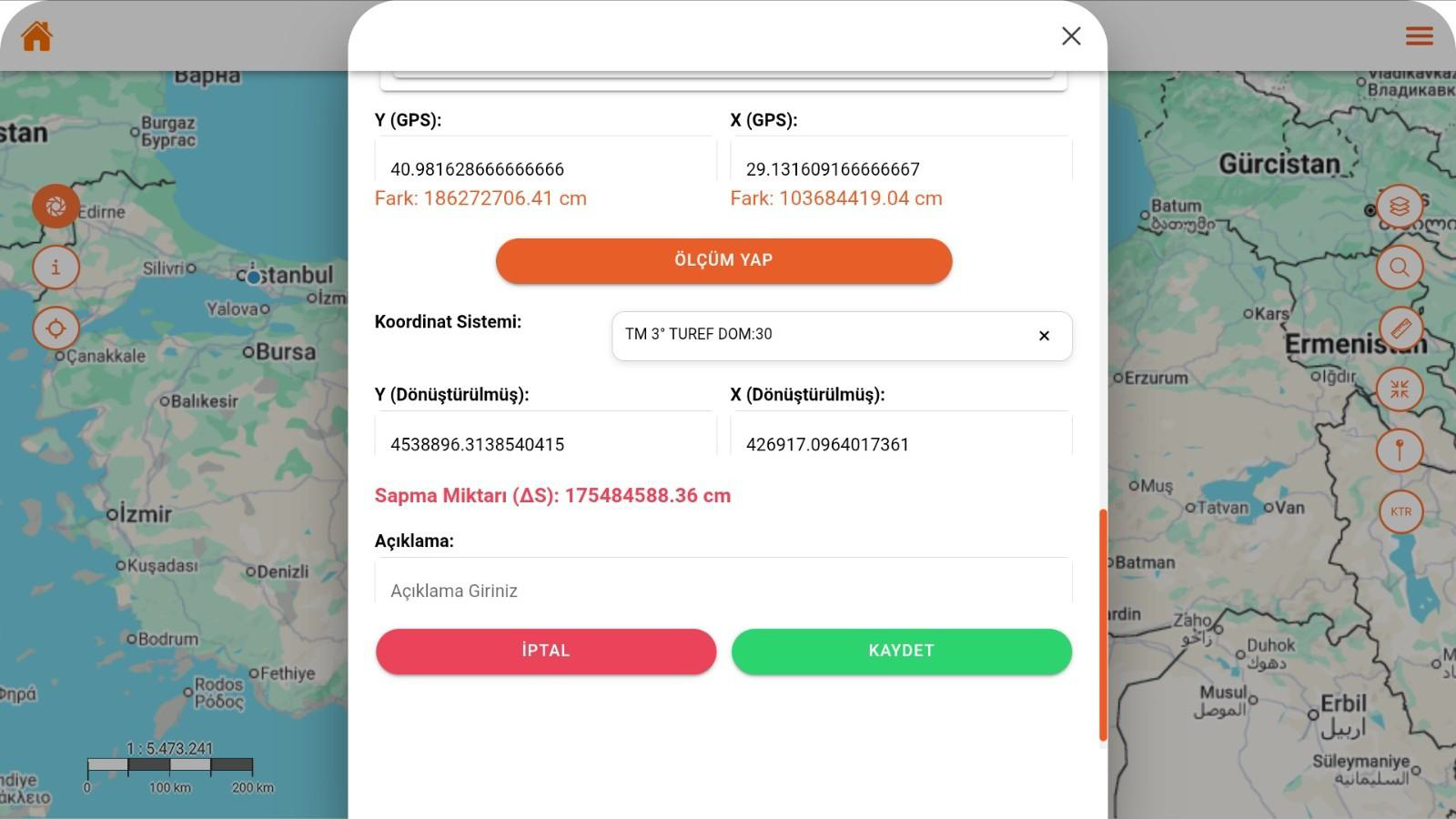
Coordinate Measurement

Coordinate Measurement Screen

The Coordinate Measurement Screen lets you track, monitor, and manage the relevant process on a single screen, in line with the corporate workflow.

Product Tour

Explore MobileGIS Application

Produce, verify, and control directly in the field

Produce, verify, and control directly in the field

Stop carrying heavy GPS devices, total stations, and measurement equipment. Make precise measurements with the tablet-integrated GPS, edit vector data, add photos and videos, verify your attribute data, access data at its source and location, lower your costs, and increase your earnings.
Project and Feature Selection

Project and Feature Selection

Field users can record location-based data by easily selecting the line and feature information of the active project. GNSS coordinates are obtained automatically, and the system produces high-accuracy position data in ITRF format.

National GNSS Network Login Screen

National GNSS Network Login Screen

Users can connect GNSS devices directly to the application by entering the IP, port, and mountpoint information of the Turkish National Permanent GNSS Network system. Thanks to the automatic connection option, fast and secure access is provided without logging in again in each session.

Turkish National Permanent GNSS Network Connection

Turkish National Permanent GNSS Network Connection

When the user successfully connects to the Turkish National Permanent GNSS Network, the system receives real-time RTK corrections and produces centimeter-accuracy positioning. The connection status is continuously monitored, and the user can disconnect and restart with a single touch if desired.

Real-Time GNSS Position

Real-Time GNSS Position

The application displays the device’s current GNSS data with high precision and analyzes position quality at the RTK level.

RTK Fixed Position Screen

RTK Fixed Position Screen

The system indicates that the GNSS receiver has switched to RTK Fixed mode, notifying the user that centimeter-level accuracy has been achieved.

Satellite Tracking Screen

Satellite Tracking Screen

All GNSS systems the device is connected to (GPS, GLONASS, GALILEO, BEIDOU, QZSS) are monitored in real time, and the number of satellites used is shown in detail.

Coordinate Measurement Screen

Coordinate Measurement Screen

This screen enables real-time measurement by converting GNSS data into the selected coordinate system. The deviation amount is calculated automatically after measurement, and the user can save the result by adding a note.

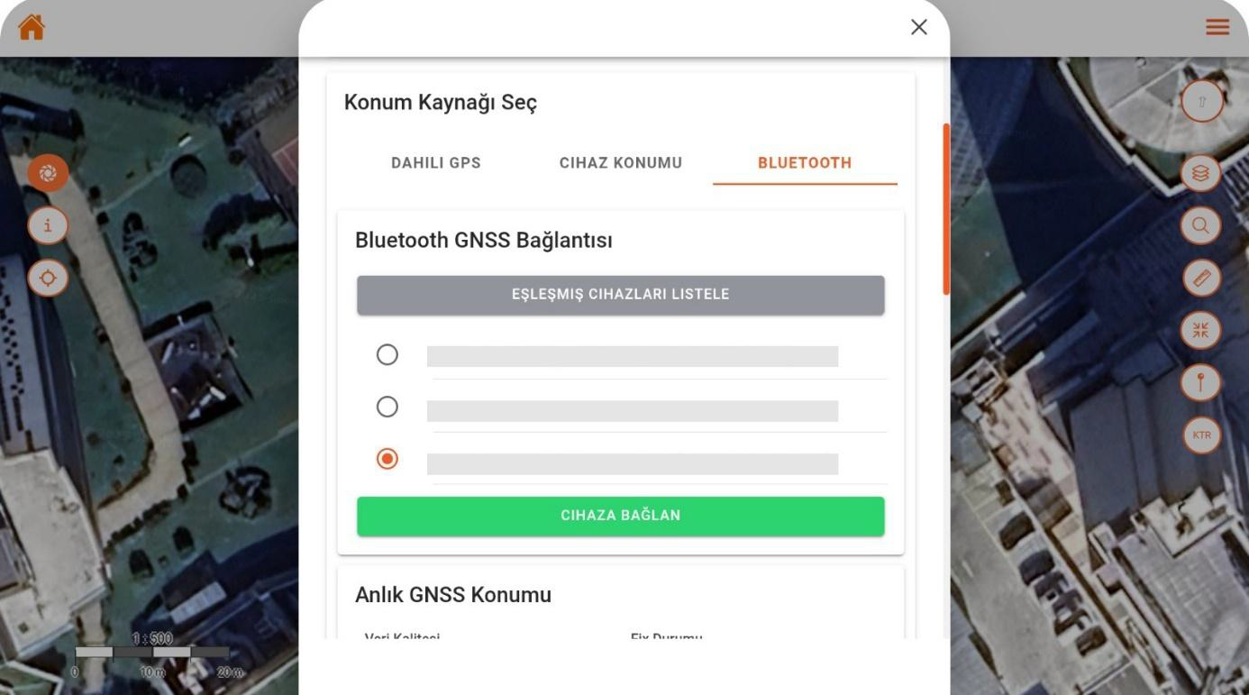
Bluetooth GNSS Connection Screen

Bluetooth GNSS Connection Screen

This screen enables external GNSS devices to connect to the mobile application via Bluetooth. The user can establish an instant connection by selecting from the list of paired devices and start receiving location data in real time.

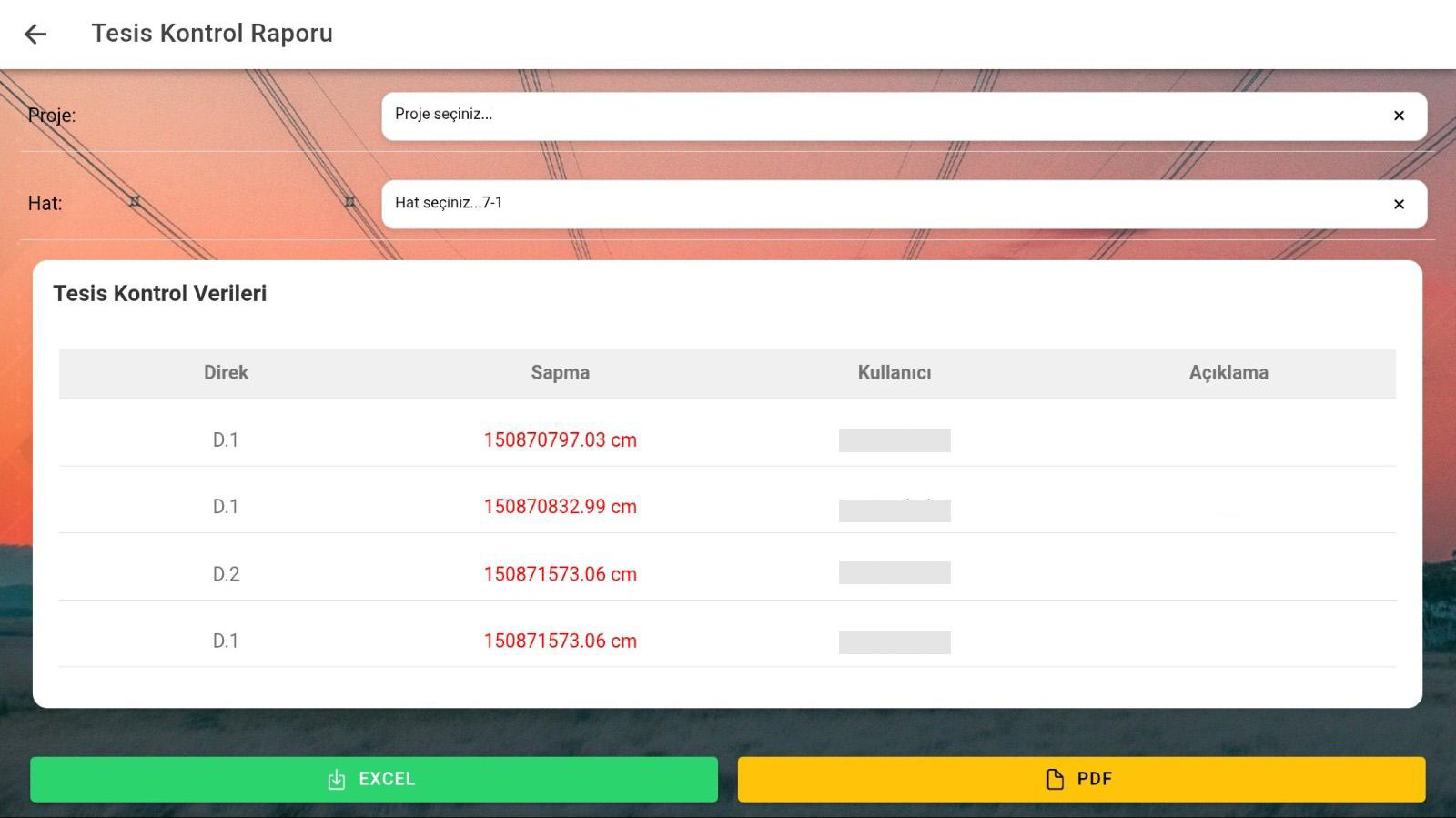
Facility Control Report Screen

Facility Control Report Screen

This screen provides control by listing pole-based deviation data obtained from measurements made in the field. Users can view the report by selecting a project and line, and export the results in Excel or PDF format.

Map

Map

It enables real-time display of field data on a geographic map. With layer management, measurement, and drawing tools, all spatial data can be managed from the field.

Format Support

Format Support

It supports WMS, WFS, GeoJSON, GPX, and SQL data formats. It allows data from different GIS infrastructures to be displayed on a single platform.

FAQ

Quick answers about MobileGIS Application

The core use cases and corporate value of the product are summarized here.

Contact Us
MobileGIS Application is a mobile-based GIS application that enables institutions to manage their field operations in an integrated way with geographic data.
It enables real-time display of field data on a geographic map. With layer management, measurement, and drawing tools, all spatial data can be managed from the field.
Field activities, tasks, and user movements can be reported through the system by location, date, and user.
It works fully integrated with Land Registry and Cadastre Information System, Spatial Address Registration System, Central Civil Registration System, Electronic Document Management System, e-signature, Enterprise Resource Planning, and OdakGIS WebGIS.
It has been developed in compliance with Municipality Law No. 5393, Metropolitan Municipality Law No. 5216, and Geographic Information Systems Law No. 6326.
It reduces your field costs. It eliminates your GPS and total station device costs. It enables you to collect comfortable, safe, and precise measurement data; and, while still in the field, to integrate the data with GIS data at the moment of first capture. It reduces your inspection and office operation costs. It increases the profitability of your company or institution.

MobileGIS Application

Digitize Your Processes,
Increase Control

MobileGIS Application is a mobile-based GIS application that enables institutions to manage their field operations in an integrated way with geographic data.

Map
Format Support
Detailed Reports
Integration Compatibility